
National Register Historic District
Quinnipiac Avenue
Explore New Haven’s historic districts HERE
Quinnipiac Avenue Historic District
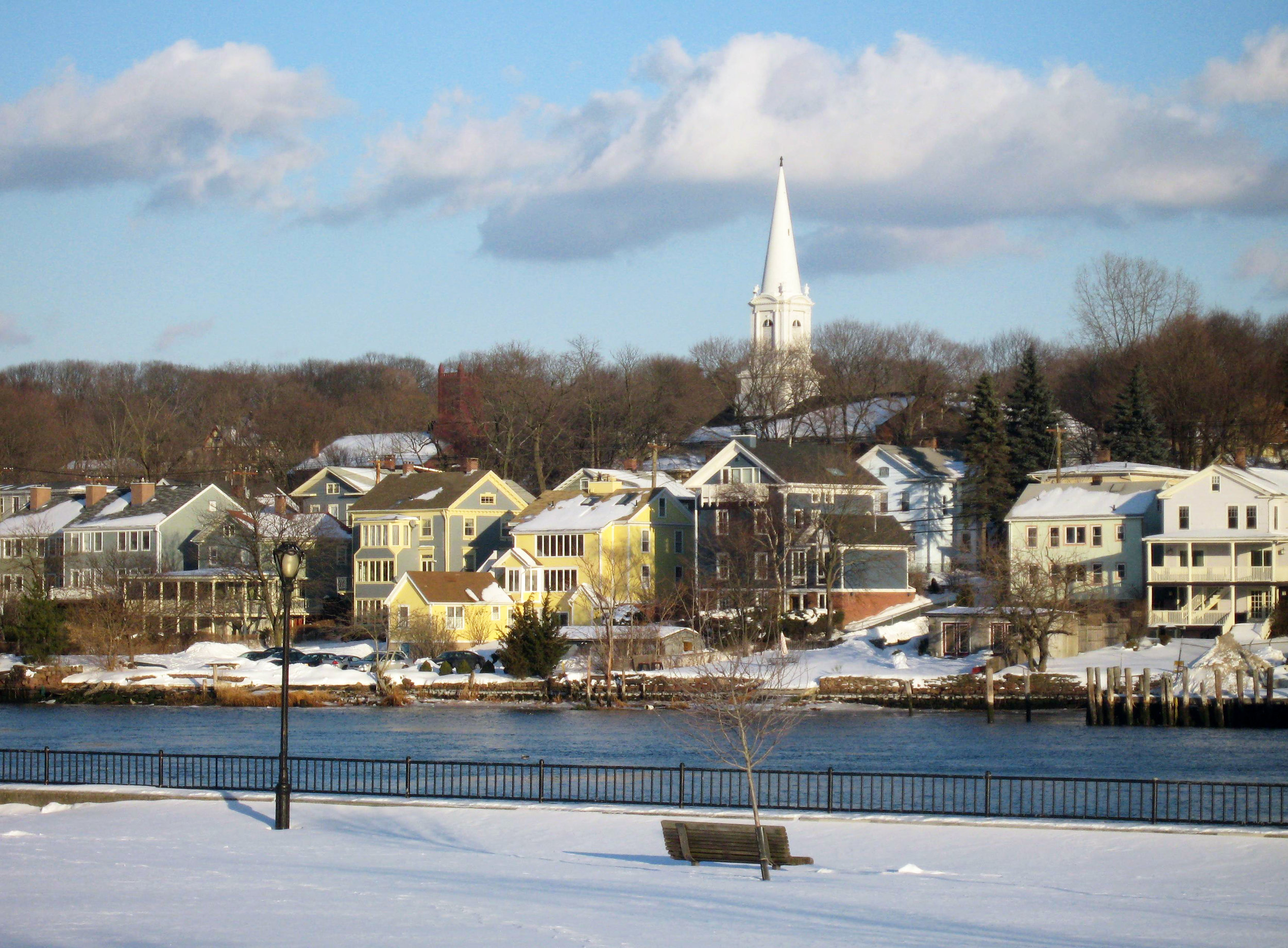
The Quinnipiac Avenue Historic District is a rare surviving example of an intact and cohesive nineteenth century maritime community. It gained prominence in the mid-nineteenth century as a major oyster port, with ancillary industries of ship building and shipping. It had its own economic and political institutions until the late nineteenth century when it was annexed to the City of New Haven. Remaining today are a great many early and mid-nineteenth century structures built by local oyster dealers, mariners, and traders. Represented in the Quinnipiac Avenue Historic District are significant examples of domestic architecture spanning a 100 year period (1785-1885). These include some of the city's best vernacular examples of Colonial, Greek Revival, Italianate, and Italian Villa styles. The Quinnipiac Avenue National Historic District was listed on the National Register of Historic Places in 1984 and overlaps the Local Historic District that was designated in 1977.
Most of the buildings in the Quinnipiac Avenue Historic District were constructed between 1780 and 1920. Although the Quinnipiac Avenue Historic District is largely residential, it also contains representative examples of the early commercial buildings, churches, and private schools as well as some of the buildings associated with the oystering industry which was the village's major focus from the 1780s until the turn of the century.
Architectural styles are represented in the Quinnipiac Avenue Historic District include Colonial, Federal, Greek Revival, Italian Villa, Italianate, Second Empire, Queen Anne, High Victorian Gothic, Gothic Revival, Romanesque, Colonial Revival and Jacobethan Revival. Physically the Quinnipiac Avenue Historic District is grouped tightly on both sides of the river around the central point of the Grand Avenue Bridge. The river is not only geographically the central feature of the Quinnipiac Avenue Historic District, but it is the dominant feature because of the terrain of the district and the orientation of the buildings. Almost every building within the Quinnipiac Avenue Historic District is in sight of the water or directly fronting on it.
The Quinnipiac Avenue Historic District has a strong residential character; however, the corridor formed by Grand Avenue/East Grand Avenue, the section of Quinnipiac Avenue two blocks north and south of the bridge and the east side of North Front Street are commercial sections. Other private and public uses, such as school and church buildings, the public library and the neighborhood cemetery and fire station are also located in these commercial sections. More than 50% of the buildings in the Quinnipiac Avenue Historic District were constructed between 1780 and 1870, the period when Fair Haven achieved its greatest significance. The earliest house in the Quinnipiac Avenue Historic District dates c.1765, and only a handful of buildings in the district date before 1800. A good example of the type of house built in the district in the late eighteenth century is the Levi Granniss House at 198 North Front Street.
Early nineteenth century styles are well represented in the district; the Stephen Rowe House and Tavern at 182-184 North Front Street and the Federal style King Block at 14 Grand Avenue exemplify early commercial buildings in the district. The early nineteenth century saw the construction of numerous small, plain, Post-Colonial houses. In Fair Haven these have little detailing which makes them recognizable as representative of a particular architectural style. These one- or two-story frame dwellings have gable roofs and are set either gable-end-to-street or with the roof ridge parallel to the street. Most are built on raised basements. This house type probably was the earliest and most common type of dwelling in Fair Haven, and the form persists into the second half of the nineteenth century. This form manifests itself despite the variety of nineteenth century architectural styles also exhibited in the district.
Fair Haven in the early days of settlement was a small community of frame buildings near the waterfront. The population boom in the early nineteenth century led to the expansion of the area beyond the tight settlement on both river banks. Although most of the buildings continued to be built of frame, some brick structures were also constructed. The earliest available maps of Fair Haven date from the late 1850s and 1860s. The picture that these maps create is that of a mixed-use community. On the west bank both sides of South Front Street were developed, with keg factories located south of the present district boundary. Oyster barns dotted the shoreline on the east side of North and South Front streets. The Coates and Barnes Oyster Market was in operation near the Grand Avenue Bridge, East Pearl Street, one of the chief residential streets in the district, had achieved a density similar to that of today, while the east side of Houston Street, particularly on the block south of Chambers, was less densely built.
Likewise, Ferry Street included more undeveloped lots than East Pearl Street. The north side of Pierpont Street, now an enclave of late nineteenth and early twentieth century houses, was largely undeveloped. Grand Avenue was largely residential and a Roman Catholic Church was located on Bright Street near the cemetery. The railroad tracks bisected Atwater Street and Clinton Avenue. In the case of Atwater Street, little development took place north of the tracks, while Clinton Avenue had widely scattered houses in the same area. Above Grafton Street, only the J.S. Farren House was standing. The lots on Pine Street between Clinton Avenue and Maltby Street were subdivided, but undeveloped. The configuration of North Front Street was much as it is today except for the east side of the street. A harness and livery shop was located near the bridge and the rest of the east side of the street was dotted with more oyster barns and the J.E. Bishop Fair Haven Oyster Depot. North of Pine Street the east side of the street was undeveloped and only three houses were located on the west side south of the Chatham Street intersection.
On the east bank, commercial buildings flanked both sides of East Grand Avenue near the bridge west of Quinnipiac Avenue. The railroad tracks crossed the river north of the Grand Avenue bridge and looped south, crossing Lenox Street two streets south of Grand Avenue and travelling south between Lenox Street and Quinnipiac Avenue. The west side of Quinnipiac Avenue was densely built all the way from the south end of the district to, but not including, the Hemingway Farm on the north end of the district. Oyster barns were common on this side of the river also. A school was located on the east side of the street at the site of the present Quinnipiac School. The Charles Ives estate was located north of #90 Clifton Avenue, marking the historical as well as the physical boundary to the district. Clifton and Lenox streets were among the most densely built residential streets. The 1859 map shows an engine depot on the northeast corner of Grand Avenue and Lenox Street, a railroad adjunct which has vanished with the tracks.
Despite the two hundred-odd years that have passed since Fair Haven was settled, an amazing number of buildings from the late eighteenth and nineteenth century oyster village have survived. Most of these are first generation buildings, that is to say, they were the first structures built on a particular site. Even though a number of early buildings were demolished along South Front Street, Exchange Street, Grand Avenue and East Grand Avenue, the quantity of remaining historic structures indicates that Fair Haven is indeed an unusual and special resource.
Click here for the National Register of Historic Places nomination file.

627 Quinnipiac Avenue